Know how MAPS of the FUTURE will solve real-life problems.

Today we will talk about the Mapping Revolution, that is expected to benefit us directly as well as indirectly in many ways.
Mapping is an integral part of our everyday lives, often in ways we might not immediately recognize. Think about how you use Google Maps to navigate through traffic, ensuring you reach your destination on time. But it doesn’t stop there. When you order food from your favorite restaurant, mapping technology helps delivery drivers find the quickest route to your doorstep, ensuring your meal arrives hot and fresh.
Similarly, when you track your Amazon parcel, mapping systems provide real-time updates on its location, giving you peace of mind about your delivery. Whether we believe it or not, mapping is deeply embedded in our daily routines, making our lives smoother and more connected.
The Changing Order
Now, what if I tell you that mapping technology is in the midst of a massive revolution? I know what you might say: “Everything is going smoothly and efficiently, so why is there even a need for change?”
Well, I largely agree with your point, but the upcoming revolution in mapping technology is expected to solve many more real-life problems with even greater ease and efficiency.
So, without wasting time, let’s dive in and understand a basic building block that will help us clearly imagine what maps and mapping technology might look like a decade from now.
Important Building Block – What are Geospatial Services?
In the simplest form, Geospatial Services are visual representations of geographic data overlayed by technology that we use to solve navigation-related problems more effectively. It is like having a supercharged map with data and technology that help us understand and make decisions about the world around us.
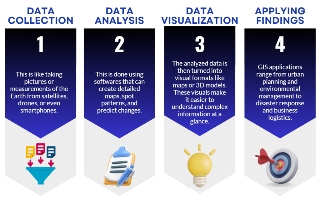
Before getting into our subject for the day, it is also important to understand the meaning of Geographic Information System (GIS) Technology. GIS Tech is a subset of Geospatial Services that integrates hardware, software, and data to capture, manage, analyze, and display geographically referenced information. GIS allows users to create layered maps and perform spatial analysis, which is essential for understanding patterns, relationships, and geographic contexts that are tied to specific locations on Earth. GIS involves the following FOUR steps.

The Revolution
To communicate simply, the revolution I am talking about is the conversion of our traditional 2D maps to 3D. Those flat maps we rely on are great for primary navigation, but they often miss out on showing depth and the genuine spatial relationships between objects. 3D maps add a whole new dimension—literally!
With 3D maps, we get a more accurate and realistic view of the world. It makes finding your way around simpler, especially during emergencies. Thanks to advanced technologies that create high-resolution 3D models from aerial images. This means we get incredibly detailed and accurate maps for environmental analysis and more.
In short, 3D maps are making our lives easier by providing a more detailed, accurate, and immersive way to understand and navigate the world around us.

3D Maps in Application
Now that we know that our maps are going 3D and how accurate data can help us better, let’s look at a few Real-Life Use Cases:
1. Utility of 3D Maps in Urban Planning
Imagine a city planning to build a new skyscraper in a densely populated urban area. Using 3D mapping technology, urban planners can create a detailed model that helps them understand how this new skyscraper can impact surroundings.
A detailed model will help them understand how the skyscraper might cast shadows on surrounding areas, assisting planners in deciding where to plant trees to mitigate heat. Planners can also analyze how the new structure will affect traffic patterns. By simulating traffic flow, planners can identify potential congestion points and design better road networks or public transportation routes to alleviate traffic issues. Another help of 3D maps can be in assessing the impact on emergency response times. Planners can ensure that fire stations, hospitals, and police stations are adequately accessible from the new skyscraper.
Another use case could be, let’s say, city planners working on a new residential complex near a river. Using 3D maps, they can simulate a heavy rainfall event and discover if water tends to accumulate in a low-lying area where they are planning to build houses. If the simulation shows a negative result, they can turn that area into a park with a large retention pond that can hold excess water during heavy rains. They can also design an advanced drainage system that channels water from the residential areas to the retention pond.
2. Telecom Infrastructure Planning
3D maps provide a detailed and realistic view of the terrain, buildings, and other structures, which is essential for planning and optimizing network coverage, especially with the rollout of advanced technologies like 5G. 3D maps help telecom companies in optimal placement of towers, network planning, supporting infrastructure management, and emergency response during outages.
Let’s say the telecom company is planning to install a new 5G cell tower in a downtown area with many high-rise buildings. Using the 3D maps, they can check if placing the tower on a particular building’s rooftop would provide excellent coverage for the surrounding area or not. However, there is also a scope to check using the map whether a nearby skyscraper would block the signal in one direction or not.
Let’s say the signal is being blocked in one direction, To solve this, the company will decide to install smaller, supplementary antennas on the sides of the skyscraper to ensure full coverage. They can also use the 3D map to plan the optimal routes for laying fiber optic cables and other ancillary infrastructure, avoiding underground utilities and minimizing disruption to the city’s traffic.
Likewise, multiple use cases of 3D maps have been discovered, and many more will be developed in the future.
Government of India’s Plan
Given its immense advantages, The Indian GoI is really pushing domestic companies to step-up, develop cutting-edge GIS technologies, and lead the way. This is because geospatial data is incredibly important for national security. By doing this, the government’s efforts could bring significant business to domestic players in this industry.
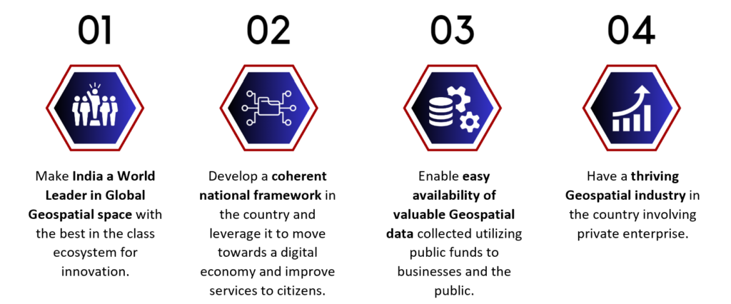
Here are the FOUR Long-Term Goals that GoI has set out:

Going further, the GoI has divided this into THREE 5-year plan of sort.
Goal for 2025 – Focus is to develop a robust FRAMEWORK and make sure that the data is AVAILABLE to all companies that could foster innovation and lead to breakthroughs in this space.
Goal for 2030 – Focus will be on generating extremely ACCURATE data and building a strong KNOWLEDGE INFRASTRUCTURE that could meet India’s need of the future.
Goal for 2035 – Focus will be on going BEYOND LAND and create a accurate Geospatial data of inland waters and sea surfaces that can support the BLUE ECONOMY of India.
If you are still with me, I am sure that by now you would be as convinced as I am regarding the promise that 3D make and cutting edge tech around the same holds.
This is definitely one space to keep a watch on as there could be some path breaking innovations that could emerge as we progress. And guess what, unlike the past, it could be an Indian company that may deliver the same.
Some companies that could benefit from the revolution:
1. C E Infosystems Ltd
2. Genesys International Corporation Ltd
3. ERP Soft Systems Ltd
4. Scanpoint Geromatics Ltd
5. Ceinsys Tech Ltd
6. Cadsys (India) Ltd.
IMPORTANT: Please note that these names are just mentioned for informational purposes. Strictly, do not take it as an investment advice.
Fin Meme of the Week
You would be lying if you said that you had not done this 😉


